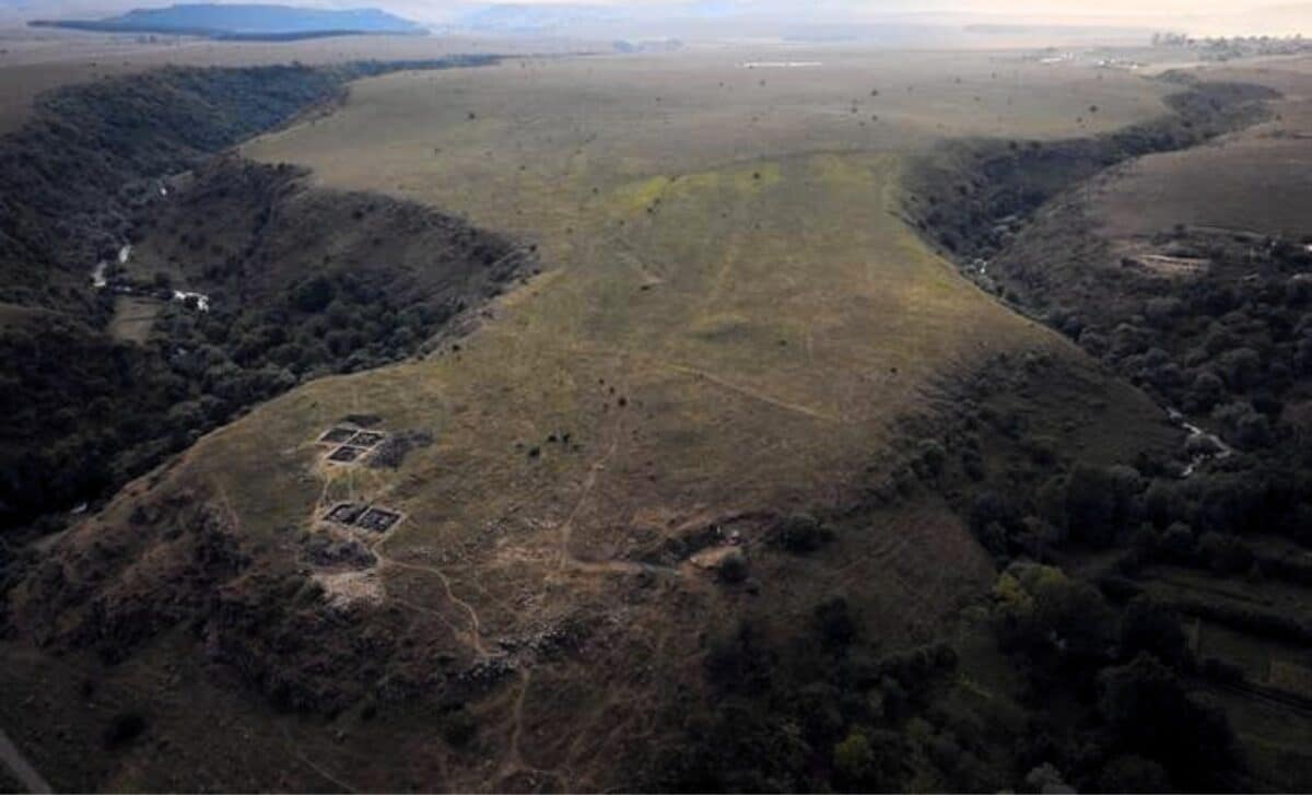
On a promontory in southern Georgia, between two deep gorges carved by ancient rivers, stone walls have stood for more than three millennia. The site, known as Dmanisis Gora, first drew the attention of archaeologists in 2018 when test excavations began on a fortified inner core. From the ground, the fortress appeared impressive but unremarkable by regional standards, a defensible position with a double wall, perhaps the seat of a local Bronze Age chieftain.
When the knee-high summer vegetation died back, researchers from Cranfield University and the Georgian National Museum noticed something unexpected. Beyond the known fortress walls, scattered across a vast plateau, lay the remains of additional fortifications and stone structures. The site was far larger than anyone had realized. From ground level, the full extent remained impossible to grasp. That limitation led to an unusual solution: a drone carrying a positioning system accurate to less than two centimeters.
The unmanned aerial vehicle flew systematic passes over 115 hectares of rugged terrain, capturing nearly 11,000 high-resolution photographs. Back in the lab, researchers stitched those images together into orthophotos’composite pictures where every point appears as if viewed straight down’and digital elevation models that revealed subtle topographic features invisible to the naked eye.
The results, published in the journal Antiquity, upended decades of assumptions about the site. Dmanisis Gora was not a 1.5-hectare fortress with a small outer enclosure. It was a mega fortress covering approximately 80 hectares, with an outer settlement defended by a 1-kilometer-long fortification wall running from gorge edge to gorge edge.
Dr. Nathaniel Erb-Satullo, senior lecturer in architectural science at Cranfield Forensic Institute and the study’s lead author, said the drone survey showed the site was more than 40 times larger than originally thought. “The use of drones has allowed us to understand the significance of the site and document it in a way that simply wouldn’t be possible on the ground.”
To confirm that the features spotted from the air were truly ancient, the team compared their drone images with 50-year-old photographs taken by a Cold War-era spy satellite declassified in 2013. That comparison helped distinguish recent agricultural features from Bronze Age structures and showed which parts of the settlement had been damaged by modern farming.