
Introduction
Welcome to the official blog of BeRAM Drones. I’m Manasvi Dhawad, an Electronics and Computer Science Engineering student at RCOEM, Nagpur. BeRAM is dedicated to developing innovative, practical, and cost-effective solutions that address real-world challenges. During my internship, I have contributed through research on Aerial Traffic Management Systems (ATMS), drafting an SRS document, analyzing dashboards and websites, and creating UI/UX designs using Figma to align with project goals.
Objective
To build a robust, intelligent airspace infrastructure that integrates aerial vehicles seamlessly, ensuring operational safety, regulatory compliance, and readiness for future aerial innovations such as drone deliveries and air taxis. This infrastructure will enable drones to communicate, coordinate, and operate safely in shared airspace, creating a unified system where real-time monitoring, automated flight approvals, and dynamic route management work together seamlessly. By establishing this foundation, we ensure that drones can perform critical missions—like surveillance, inspection, medical supply delivery, and emergency response—without interfering with manned aircraft or ground operations. This objective positions the ATMS as a future-ready backbone for large-scale drone adoption and urban air-mobility advancements.
Why ATMS is Needed?
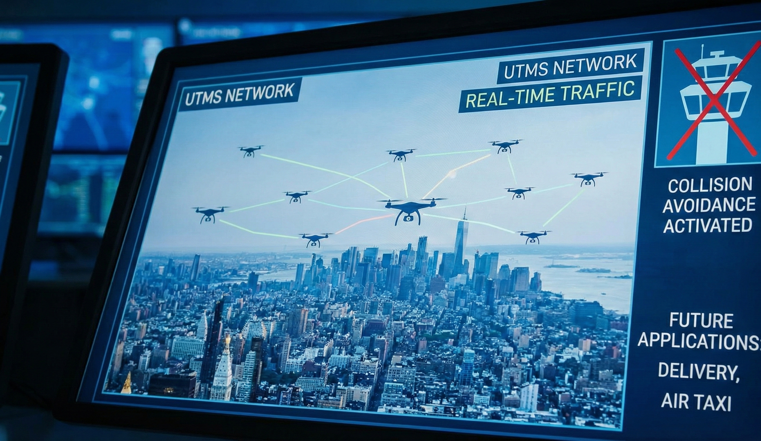
- Rapid rise in drone usage across industries
- Prevents mid-air collisions and airspace violations
- Traditional ATC can't manage drone-scale traffic
- ATMS enables safe, real-time drone coordination
- Supports future applications like drone delivery and air taxis
- Ensures Beyond Visual Line of Sight (BVLOS) operations
- Creates a structured digital airspace
- Offers real-time airspace awareness
Other ATMS Innovations & Technical Bases
1. Altitude Angel (UK) – Real-time AI-powered conflict resolution and U-Space compliance.
2. ANRA Technologies (India/USA) – Blockchain-based UTM integration with FAA & Digital Sky.
3. Terra Drone (Japan) – GIS-based obstacle detection and centralized airspace routing.
Key Technical Components
- Real-time telemetry data with geofencing
- AI-powered collision avoidance
- Integration with manned aviation systems
ATMS continuously collects drone position, altitude, velocity, and battery health, creating a dynamic 3D map of the airspace. Geofencing ensures that drones automatically avoid restricted zones such as airports, military bases, and sensitive urban areas.
Advanced AI algorithms analyze drone trajectories in real time, predicting possible conflicts before they occur. The system autonomously performs route changes, altitude adjustments, and speed modulation to maintain safe separation between all UAVs.
ATMS synchronizes drone activity with existing Air Traffic Management (ATM) systems. This allows safe coexistence with helicopters, air ambulances, and future eVTOL aircraft by prioritizing emergency flights and maintaining secure separation layers.
Conclusion
Building a ATMS aligns with BeRAM’s mission to lead in deep-tech research and contribute to safer airspace management. It positions BeRAM as a pioneer in India's drone ecosystem, unlocks funding opportunities, and supports scalable innovation in drone logistics and AI-driven aviation solutions. By establishing a unified digital infrastructure, BeRAM accelerates the transition toward smarter cities where drones handle critical missions such as emergency response, infrastructure inspection, and medical deliveries with unmatched efficiency.